There was little drama surrounding Tropical Storm Cristina’s announcement. On a Monday in early June 2026, it just appeared silently and without fanfare in the warm waters of the Eastern Pacific off the coast of Nicaragua. Maximum sustained winds of 45 miles per hour, centered about 105 miles west-northwest of Managua, were first reported by the National Hurricane Center in Miami. Nearly instantly, a tropical storm warning was issued, extending from Puerto Sandino to the border between Guatemala and El Salvador. Meteorologists are kept up at night by the combination of rapid formation and proximity to populated coastline.
Even though the storm posed a real threat, it wasn’t the storm itself that made Cristina’s arrival worthwhile. It was what was keeping an eye on things. As part of a larger effort to develop real-time ocean intelligence in an area where traditional buoy networks have always had gaps, NOAA’s expanding fleet of unmanned systems, including autonomous surface vehicles, underwater gliders, and aerial drones, had been discreetly repositioned ahead of the 2026 Eastern Pacific hurricane season. These systems were already in the air and on the water when Cristina spun up, providing forecasters with data at a density that was simply unmatched by older infrastructure.
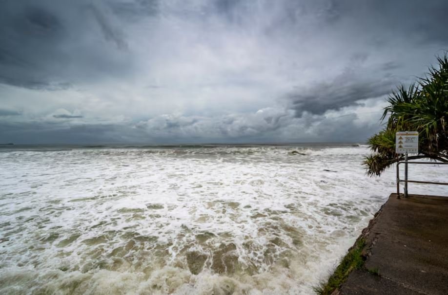
It’s difficult to ignore how much storm tracking mechanics have changed in recent years. Forecasters once mainly relied on aircraft recon flights and satellite passes, both of which were useful but not constant. A different type of situational awareness is demonstrated by an unmanned surface vehicle that drifts ahead of a developing storm and measures wind shear and sea surface temperatures in nearly real time. Scheduled check-ins are not supported by the ocean. Because Cristina moved slowly, hugging the Nicaraguan coast and refusing to disperse cleanly, the data stream needed to be continuous rather than sporadic.
Over several days, the storm’s predicted path took it northwest along the coast of Central America, passing through Guatemala, El Salvador, and Honduras. INETER’s Nicaraguan meteorological authorities initiated ongoing monitoring procedures. Communities close to rivers and steep terrain were placed on alert by SINAPRED, the national disaster prevention system. The prolonged rainfall totals—four to eight inches in coastal zones, with isolated areas possibly receiving twelve inches—were more concerning than direct landfall. That math quickly becomes hazardous on saturated soil.
Cristina’s convection had intensified by Tuesday, as evidenced by loops in GOES satellite imagery that went viral on social media. The storm didn’t need to become a hurricane, but it wasn’t. Flooding and mudslides were the main risks due to the mountainous terrain, slow movement, and persistent cloud bands. In these situations, post-storm analysis frequently shows that wind speed had little bearing on the actual damage.
Tropical Storm Boris, which was spinning off Mexico at the same time as Cristina and was predicted to make landfall there that same week, was the second Eastern Pacific storm in action at the time. A reminder of why the 2026 season was predicted to be above-average before it even began was provided by two named systems in the same basin in early June, both of which affected distinct sections of a coastline that stretches from Mexico through Central America.
The National Hurricane Center released its last advisory early on Thursday morning. Cristina had weakened into a trough close to El Salvador’s coast, with winds as low as 25 miles per hour and a central pressure of up to 1007 millibars. The system was implemented as a named storm. However, the forecasters carefully noted that the remnants were still capable of causing potentially fatal flash floods in El Salvador through that night—the kind of warning that doesn’t make headlines but probably ought to.
Beyond the rainfall totals, Cristina leaves behind a data record. Ocean temperature profiles, surface wind measurements, and wave data were gathered by the unmanned platforms that followed it through formation and decay. These data will be used for months to verify the model. This type of detailed, ongoing observation may alter the forecast for the next Cristina, making it slightly earlier and more accurate. Slightly frequently means a lot in storm science.