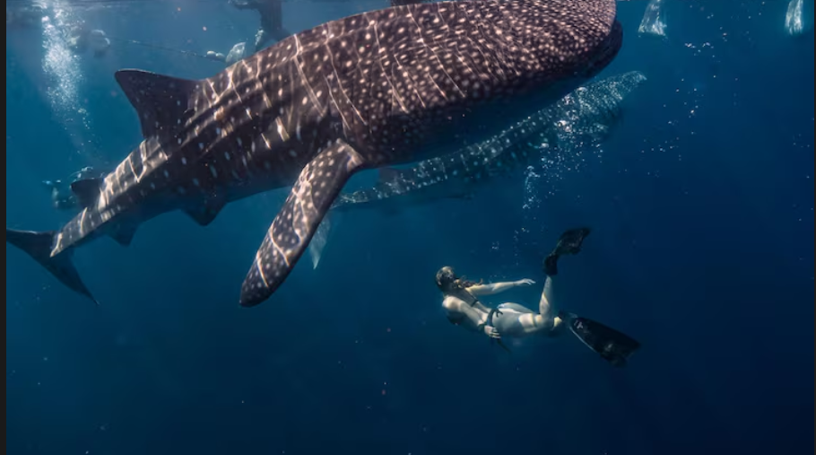
At Darwin Island, one of the world’s most isolated dive sites, about 600 miles off the coast of mainland Ecuador, something subtly remarkable is taking place. Three times a day, a team of researchers descends on a scuba dive, lands on a platform made of submerged rock, and waits. They are pulled by powerful currents. Visibility changes. Then, out of nowhere, a 12-meter whale shark appears out of nowhere. It is massive, leisurely, and doesn’t seem to realize how uncommon it is. It’s not just awe that follows. Science is involved. In particular, it’s a photograph, and it might be accomplishing something that NOAA’s most advanced satellite systems actually aren’t able to.
Since 2011, the Galapagos Whale Shark Project has conducted yearly trips to Darwin and Wolf Islands, developing a photo-identification database that currently contains almost 700 uniquely identified whale sharks from the archipelago, some of which were resighted after four, nine, or even twelve years. In contrast, satellite tags last for months rather than years. It’s not close math. A fin-mounted tag may transmit for three or four months before being crushed by pressure when the animal dives deeper than 1,700 meters or dislodged by a silky shark using the whale shark as a scratching post.
Once a photo is added to the Wildbook for Whale Sharks database, it remains there forever. No satellite signal can duplicate the pattern data it carries from the animal’s distinctive spot markings. It’s difficult to ignore how sophisticated that is—the oldest biological trick, identification by appearance, outlasting the newest hardware. Quasar Expeditions To avoid the logistical challenges and expense of satellite tagging, organizations such as the Galapagos Whale Shark Project use photo identification to passively tag and track whale sharks.
This is very important because the population under study is not just any whale shark population. Ninety-nine percent of the animals seen around Darwin Island are adult females, many of which appear pregnant. Every year, the Galapagos Marine Reserve is home to a sizable population of mostly female whale sharks, 90% of which appear to be pregnant. However, scientists are still unsure of the reasons behind their congregation. Every picture matters in part because of that mystery. Every picture is a piece of information in a long-running puzzle about the location of the world’s largest fish’s breeding, childbirth, and upbringing—events that no one has ever really seen.
FstoppersGalápagos Conservancy The project’s satellite tagging component has also yielded truly impressive results, but it has humble limitations. Researcher Sofía León discovered that the sharks tracked from the Galapagos were congregating off Peru between December and February—possibly a crucial feeding area—after analyzing movement data from her master’s thesis in Portugal.
The tags also revealed an unexpected finding: the sharks stay relatively shallow off the Peruvian coast, rarely surpassing 300 meters, but dive deep near the Galapagos, occasionally surpassing 1,000 meters. It could be a change in feeding strategy. However, the technology just breaks after a certain depth. The tags are crushed. The song comes to an end. A satellite tag can continue where it left off with a photograph taken at Darwin three years later.
Hope, a whale shark, is the subject of the project’s most poignant tale. Hope’s tag was one of the more than USD 112,000 that Galapagos Shark Diving has donated since 2019 to support satellite tags, ultrasound research, and long-term whale shark monitoring. As she moved away from the Galapagos and then abruptly stopped transmitting, researchers made her location data public. This data suggested that she had been captured by a fishing vessel. The reaction was worldwide. Those who had been following her on social media and were able to identify her face from project photos were taken aback. A portion of China’s fishing fleet was recalled.
A single whale shark, identified by name and photograph, turned into a conservation argument that could not have been made with just satellite data. Galapagossharkdiving is a non-invasive technique that enables tracking of movements, population estimates, and long-distance migrations across oceans. By contributing images or videos of whale sharks to the project, citizen scientists assist researchers in identifying individual animals through their distinctive markings. Today, dive guides from all over the archipelago actively collaborate, sharing photos from each trip.
No single government agency has the resources or personnel to duplicate the work being done by this dispersed network of photographers. Additionally, the project was the first to use underwater ultrasound and blood sampling to investigate the biology of whale shark reproduction in the wild. The team’s ability to determine whether adult females they come across are pregnant—a question with significant conservation implications—was enhanced in 2025 when they purchased a new ultrasound unit. Galapagos Conservation Trust Marine Megafauna Foundation Observing this project from the outside gives the impression that it is a sort of correction to the way marine science has been conducted for decades, pursuing technological solutions to issues that occasionally respond better to patience, presence, and a camera.
Telemetry from satellites is very effective. The use of electronic tags by NOAA has revolutionized our knowledge of large whale species. However, the photograph is currently the more comprehensive record for an animal that travels across jurisdictions more quickly than fleets can react, dives deeper than the tags can survive, and returns to the same island 12 years later looking exactly the same. At depth, it doesn’t crush. It doesn’t come off. It simply waits for the shark to return in a database.