The Rockies’ refusal to adhere to a calendar has an almost theatrical quality. The first official backyard get-together of the year, charcoal smoke, and sunburned shoulders are all expected during Memorial Day weekend. Rather, a large portion of the West is witnessing yet another round of winter, and the forecast does not appear to be making an apology.
The timing is what causes people to hesitate, even though the system itself is not very unusual in shape. While a second trough further south is unwilling to let go, an upper trough that is sliding down from western Canada is dipping into the northern Rockies and bringing cold moisture across Montana, Wyoming, and northern Colorado. Instead of a quick punch, the outcome is a long-lasting, slow-grinding storm. Parts of the high country may resemble early March rather than late May by the time it lifts.
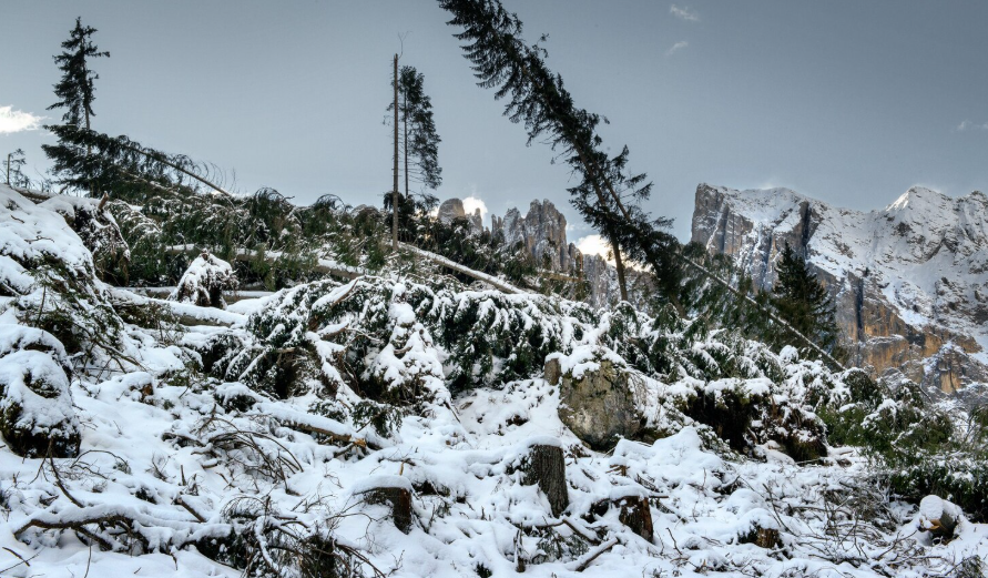
The Absaroka and Beartooth Mountains in southern Montana are under a winter storm warning, with Cooke City at its center, according to the National Weather Service in Billings. With wind gusts of up to 30 mph and eight to thirteen inches predicted, the office’s own description of how recreation in the high country “will be impacted” reads almost as an understatement. The Riverton office is requesting up to fourteen inches over the course of two days up at Beartooth Pass and Gannett Peak. Observing the accumulation of bulletins gives the impression that forecasters are attempting to be measured while the numbers themselves continue to rise.
The story takes a sharp turn in Colorado. The Weather Prediction Center reports heavy, wet snow covering the Central Rockies, and the same Pacific trough that blocked over two hundred miles of I-80 in southern Wyoming on Monday has reloaded over the Colorado Rockies. The obvious pressure points are the West Slope and the I-70 corridor. In the anticipated scenario, the Continental Divide totals are 12 to 18 inches, with the highest peaks measuring 18 to 24 inches. A private model from Mountain-Forecast is whispering something closer to forty-nine inches on Longs Peak through Thursday night, while the premium NWS outlook pushes Longs Peak and Mount Blue Sky into the 24 to 30 inch range. In the final week of May, that figure seems almost ridiculous.
Tuesday afternoon through Wednesday morning is when driving danger is at its highest. The rhythm of the Eisenhower Tunnel approach in bad weather is familiar to anyone who has driven it: brake lights stacking in the dark, semis crawling, and the dashboard temperature gauge sliding into the teens once you reach ten thousand feet. Both Vail Pass and Berthoud Pass experience bitter overnight lows, drifting, and a lot of snow. It’s difficult to ignore the fact that most tourists intended to spend their holiday weekend along this exact stretch.
The storm has a different appearance down in the cities. The majority of the forecast for Denver, Boulder, and Fort Collins is rain, with the occasional wet snowflake mixed in during the heavier spells. About 0.20 to 0.40 inches of rain have already fallen on the Front Range, and more is on the way. At lower elevations, the freeze that is encroaching behind the storm is more concerning than accumulation. From Fort Collins through Greeley, Loveland, Sterling, Akron, and Fort Morgan, a Frost Advisory covers the northeastern plains. This is the type of week that ends with sheets thrown over tomato cages and a silent curse at the thermometer for gardeners who planted early.
What clingy, wet snow does to trees that have already lost their leaves is another concern. Crews typically position equipment before the first heavy branches start to fall because power utilities near the I-70 ski towns are familiar with that script. By Wednesday, outage maps will likely reflect whether they completed the task on time.
It would be easy to label this as freakish as you watch it play out, but the Rockies have always done this. Even though every generation seems to be slightly offended by May storms, they are a part of the local memory. Eventually, there will be cookouts. For now, the mountains have different ideas.